I-5, I-90, and I-82 Explained
Washington’s freight network is the lifeline of the Pacific Northwest economy. Three interstate highways — I-5, I-90, and I-82 — form the backbone of trucking operations across the state, connecting ports, agricultural centers, manufacturing hubs, and border crossings.
Interstate 5 (I-5) – The West Coast Freight Corridor
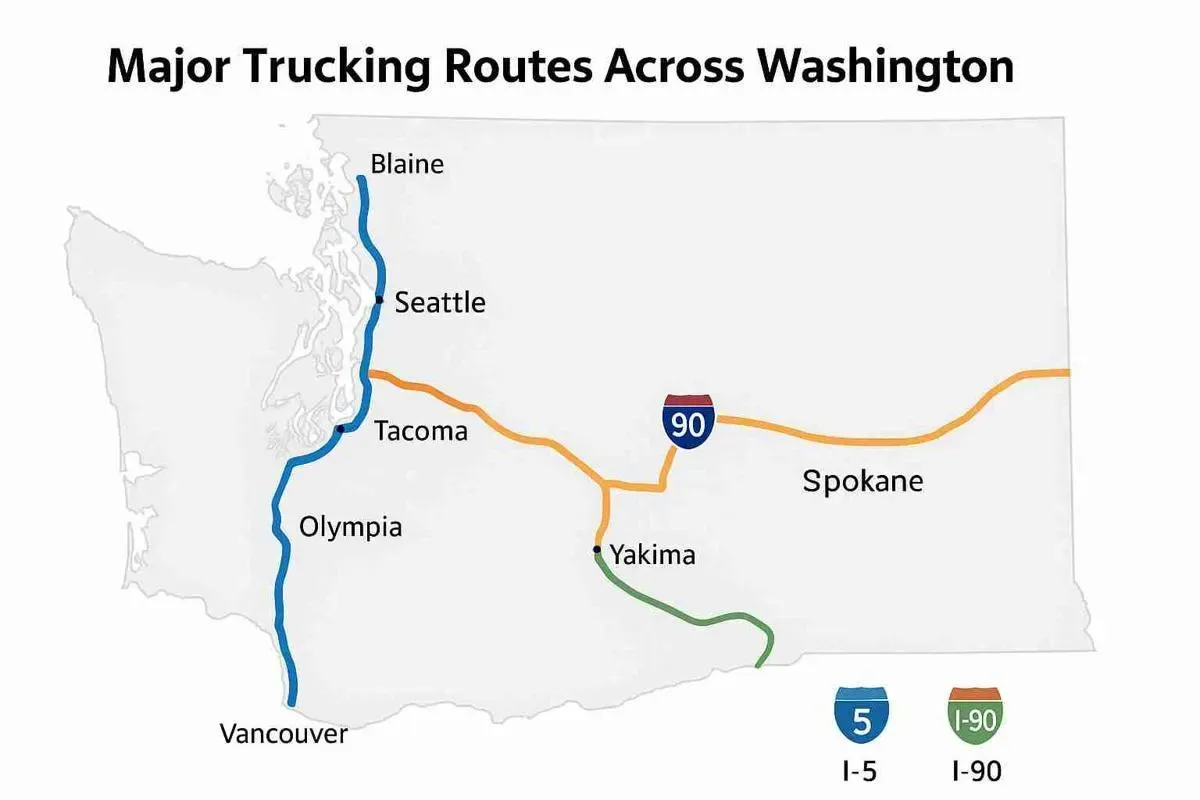
Route: Runs north–south from the Canadian border (Blaine, WA) to the Oregon border (Vancouver, WA)
Length in Washington: ~276 miles
Key Freight Links:
-
Connects Seattle, Tacoma, Olympia, and Vancouver
-
Links major ports (Seattle, Tacoma, Everett) with distribution centers
-
Connects to Canadian trade routes via the Pacific Highway Border Crossing
-
Serves as the main corridor for consumer goods, electronics, and perishables
Why It Matters:
I-5 is Washington’s busiest trucking route, handling a high percentage of both intrastate and interstate freight. It’s vital for cross-border trade with Canada and for shipments moving south toward California.
Challenges:
-
Heavy congestion around Seattle and Tacoma
-
Limited truck parking
-
Frequent construction and weather-related delays
-
Strict weight and emissions regulations in urban zones
Interstate 90 (I-90) – The Cross-State Gateway
Route: Stretches east–west from Seattle through Snoqualmie Pass to Spokane, then into Idaho
Length in Washington: ~298 miles
Key Freight Links:
-
Primary connection between Puget Sound ports and Eastern Washington
-
Carries agricultural goods, manufacturing materials, and retail freight
-
Connects to I-5 in Seattle and continues to the Midwest and East Coast
Why It Matters:
I-90 is the only east–west interstate crossing the Cascade Mountains, making it essential for moving Washington’s exports — wheat, fruit, timber, and machinery — to national markets.
Challenges:
-
Snoqualmie Pass (elevation 3,022 ft) often faces snow, ice, and closures in winter
-
Steep grades demand careful load and brake management
-
Chain-up requirements in winter months
-
Rest area and service limitations in mountain stretches
Interstate 82 (I-82) – The Agricultural Connector
Route: Runs from I-90 near Ellensburg through Yakima and Tri-Cities (Kennewick, Pasco, Richland) to the Oregon border near Umatilla
Length in Washington: ~144 miles
Key Freight Links:
-
Connects Washington’s agricultural heartland (Yakima Valley, Columbia Basin) to I-84 in Oregon
-
Critical for ag exports, especially apples, hops, wheat, and wine
-
Links regional farms to Port of Portland and Columbia River barge terminals
Why It Matters:
I-82 is the agricultural lifeline of Washington, enabling efficient movement of perishables and bulk commodities to ports and distribution hubs.
Challenges:
-
Summer heat affects refrigeration efficiency
-
Seasonal spikes in truck traffic during harvest
-
Limited alternate routes during closures or detours